![](/images/other/stat-length.png)
![Trail On foot Loška Dolina - Pot prijateljstva Snežnik-Snježnik - Photo](https://media.geolcdn.com/t/1900/400/454ce306-fc2c-43e2-8038-3237620763ce.jpeg&format=pjpeg&maxdim=2)
Pot prijateljstva Snežnik-Snježnik
SityTrail - itinéraires balisés pédestres
Tous les sentiers balisés d’Europe GUIDE+
![Length](/images/other/stat-length.png)
Length
28 km
![Max alt](https://static1.geolcdn.com/siteimages/upload/files/1508320355ic_sort_altitude_max_24dp.png)
Max alt
1771 m
![Uphill gradient](https://static1.geolcdn.com/siteimages/upload/files/1508320355ic_sort_den_pos_24dp.png)
Uphill gradient
832 m
![Km-Effort](/images/other/stat-length.png)
Km-Effort
40 km
![Min alt](https://static1.geolcdn.com/siteimages/upload/files/1508320355ic_sort_altitude_min_24dp.png)
Min alt
1155 m
![Downhill gradient](https://static1.geolcdn.com/siteimages/upload/files/1508320355ic_sort_den_neg_24dp.png)
Downhill gradient
1127 m
![Boucle](https://static1.geolcdn.com/siteimages/upload/files/16400158638029165_repeat_loop_refresh_sync_direction_icon.png)
Boucle
No
Signpost
Creation date :
2025-02-07 21:19:06.623
Updated on :
2025-02-07 21:19:06.623
![On foot](https://static1.geolcdn.com/sitytour/trail-icons/100.png)
9h04
Difficulty : Difficult
![Scan this QR Code to open this trail in the SityTrail application](https://capi.geolives.com/qq0zvz2zws4bq2lad0pu/sitytour/trails/4346791/qr.png?size=200)
FREE GPS app for hiking
About
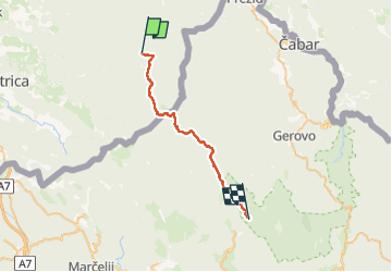
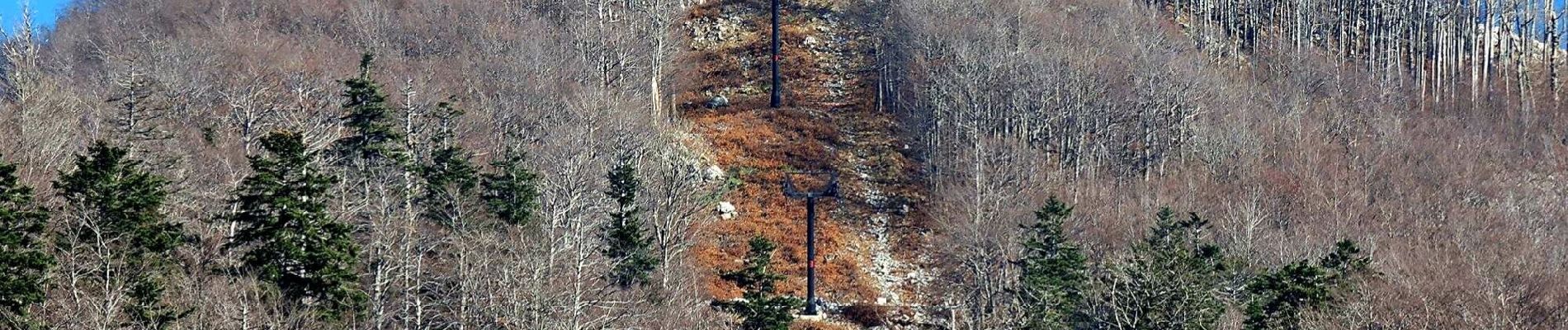
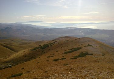
Trail On foot of 28 km to be discovered at Unknown, Unknown, Loška Dolina. This trail is proposed by SityTrail - itinéraires balisés pédestres.
Description
Trail created by Planinsko društvo Snežnik Ilirska Bistrica, PD Platak Rijeka.
Positioning
Country:
Slovenia
Region :
Unknown
Department/Province :
Unknown
Municipality :
Loška Dolina
Location:
Unknown
Start:(Dec)
Start:(UTM)
456888 ; 5048408 (33T) N.
Comments
Trails nearby
![Trail On foot - Saršoni - Studena - Photo](https://media.geolcdn.com/t/375/260/dbbd9bec-d8f7-4124-bf49-f7a77d949ce1.jpeg&format=jpg&maxdim=2)
![On foot On foot](https://static1.geolcdn.com/sitytour/trail-icons/100.png)
Saršoni - Studena
On foot
Easy
,
Unknown,
Primorje-Gorski Kotar County,
Croatia
![](/images/other/stat-length.png)
3.8 km | 4.4 km-effort
59min
![](https://static1.geolcdn.com/siteimages/upload/files/16400158638029165_repeat_loop_refresh_sync_direction_icon.png)
No
![Trail On foot - Gornje Jelenje - Fužine - Photo](https://media.geolcdn.com/t/375/260/bc446bdd-3cfe-45c0-94f3-3ba2d4e990b4.jpeg&format=jpg&maxdim=2)
![On foot On foot](https://static1.geolcdn.com/sitytour/trail-icons/100.png)
Gornje Jelenje - Fužine
On foot
Medium
,
Unknown,
Primorje-Gorski Kotar County,
Croatia
![](/images/other/stat-length.png)
18.4 km | 29 km-effort
6h 36min
![](https://static1.geolcdn.com/siteimages/upload/files/16400158638029165_repeat_loop_refresh_sync_direction_icon.png)
No
![Trail On foot - National park Risnjak - Photo](https://media.geolcdn.com/t/375/260/d7f43ced-7746-4c3c-aa97-9c953327d62b.jpeg&format=jpg&maxdim=2)
![On foot On foot](https://static1.geolcdn.com/sitytour/trail-icons/100.png)
National park Risnjak
On foot
Difficult
,
Unknown,
Primorje-Gorski Kotar County,
Croatia
![](/images/other/stat-length.png)
24 km | 40 km-effort
9h 1min
![](https://static1.geolcdn.com/siteimages/upload/files/16400158638029165_repeat_loop_refresh_sync_direction_icon.png)
No
![Trail On foot - Tršće - Sveta gora - Source of Kupa - Crni Lug - Photo](https://media.geolcdn.com/t/375/260/60013492-baa6-4369-bcba-b910bef47edc.jpeg&format=jpg&maxdim=2)
![On foot On foot](https://static1.geolcdn.com/sitytour/trail-icons/100.png)
Tršće - Sveta gora - Source of Kupa - Crni Lug
On foot
Medium
,
Unknown,
Primorje-Gorski Kotar County,
Croatia
![](/images/other/stat-length.png)
15.3 km | 24 km-effort
5h 25min
![](https://static1.geolcdn.com/siteimages/upload/files/16400158638029165_repeat_loop_refresh_sync_direction_icon.png)
No
![Trail On foot - Prezid - Čabar - Tršće - Photo](https://media.geolcdn.com/t/375/260/63396e8a-0219-4975-8a92-2dc12ba77793.jpeg&format=jpg&maxdim=2)
![On foot On foot](https://static1.geolcdn.com/sitytour/trail-icons/100.png)
Prezid - Čabar - Tršće
On foot
Easy
,
Unknown,
Primorje-Gorski Kotar County,
Croatia
![](/images/other/stat-length.png)
4.9 km | 7.1 km-effort
1h 36min
![](https://static1.geolcdn.com/siteimages/upload/files/16400158638029165_repeat_loop_refresh_sync_direction_icon.png)
No
![Trail On foot - OH 15 - Photo](https://media.geolcdn.com/t/375/260/9b4194d2-19d6-4583-806e-0f711ce103ee.jpeg&format=jpg&maxdim=2)
![On foot On foot](https://static1.geolcdn.com/sitytour/trail-icons/100.png)
OH 15
On foot
Easy
,
Unknown,
Primorje-Gorski Kotar County,
Croatia
![](/images/other/stat-length.png)
4.7 km | 7.5 km-effort
1h 41min
![](https://static1.geolcdn.com/siteimages/upload/files/16400158638029165_repeat_loop_refresh_sync_direction_icon.png)
No
![Trail On foot - Obilježen planinarskom stazom - Photo](https://media.geolcdn.com/t/375/260/dbbd9bec-d8f7-4124-bf49-f7a77d949ce1.jpeg&format=jpg&maxdim=2)
![On foot On foot](https://static1.geolcdn.com/sitytour/trail-icons/100.png)
Obilježen planinarskom stazom
On foot
Easy
,
Unknown,
Primorje-Gorski Kotar County,
Croatia
![](/images/other/stat-length.png)
5.4 km | 6.6 km-effort
1h 29min
![](https://static1.geolcdn.com/siteimages/upload/files/16400158638029165_repeat_loop_refresh_sync_direction_icon.png)
No
![Trail On foot - Potkilvac - Zapodi-Halić - Photo](https://media.geolcdn.com/t/375/260/d3d063af-e7e5-4024-b9b5-6f97f93004ac.jpeg&format=jpg&maxdim=2)
![On foot On foot](https://static1.geolcdn.com/sitytour/trail-icons/100.png)
Potkilvac - Zapodi-Halić
On foot
Easy
,
Unknown,
Primorje-Gorski Kotar County,
Croatia
![](/images/other/stat-length.png)
4.1 km | 6.6 km-effort
1h 29min
![](https://static1.geolcdn.com/siteimages/upload/files/16400158638029165_repeat_loop_refresh_sync_direction_icon.png)
No
![Trail On foot - Potkilvac - Mudnaj dol - Gorničko - Halić - Photo](https://media.geolcdn.com/t/375/260/dea22dc6-3eb5-40f6-98dd-032c98fe4d60.jpeg&format=jpg&maxdim=2)
![On foot On foot](https://static1.geolcdn.com/sitytour/trail-icons/100.png)
Potkilvac - Mudnaj dol - Gorničko - Halić
On foot
Easy
,
Unknown,
Primorje-Gorski Kotar County,
Croatia
![](/images/other/stat-length.png)
5.9 km | 8.2 km-effort
1h 52min
![](https://static1.geolcdn.com/siteimages/upload/files/16400158638029165_repeat_loop_refresh_sync_direction_icon.png)
No